Lake effect snow is mainly a numbers game.
That magic number for Lake Erie being roughly 15 degrees Fahrenheit.
With enough moisture and winds out of the Northeast, lake effect snow is possible for our area in the winter. However, we could still see lake effect snow into spring. Here’ why:
Water Temperatures and Ice
Currently Lake Erie’s water temperature is, on average, 33º F. This is the starting point for lake effect snow.

If the lake temperature was 32º F, or lower, then the surface of the lake would begin to freeze. In January the lake was roughly 85% covered in ice with the cold snaps.
If the lake if covered in ice then there can’t be lake effect snow. Just like a lid on a cup of water, you won’t me able to reach the liquid if there is something blocking the transfer of water. This is good for preventing spills, but bad for creating lake effect snow.
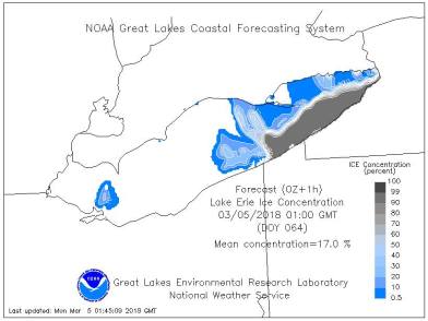
The lake is currently 17% covered with ice. This means that there is no “top” to cut off the lake effect snow.
Remember that magic number we started with?
15º F
Let’s do some simple math.
Air Temperature
We just established that the lake temperature is roughly 33º F. So where does 15º F come in?
15º F is the difference needed between lake to air temperatures to create to lake effect snow. Lake effect snow bands are stronger when the temperature difference is greater.

Have you ever got out of a hot tub on a cold day and notice the steam coming off of you?
Lake effect snow works the same way. When it is cold outside the warmer air, near the surface of the lake, wants to rise and take the moisture with it. When water rises it condenses (i.e. forms clouds) and the clouds move over land. Then snow is produced if the air temperatures is below 32º F.
Right now we have lake temperatures at 33º F and we need air temps to be 15º colder to get lake effect snow to kick up.
33º F (Average Lake Temperatures) – 15º F (Temperature Difference) = 17º F (Air Temperature Needed)
So does that mean we need the air temperature to be 17º F for LES? Yes, but not surface temperatures.
850mb Temperatures
One of the misconceptions with lake effect snow is that we need to 15º difference to be at the surface, but it actually needs to be the difference with the air temperature above our heads.
Meteorologists don’t measure height in the atmosphere in miles but in pressure. I know it sounds really confusing and it can be. It’s a lot to explain right now, but I want you to understand that 850 millibars is approximately 1 mile above us.

Looking at a 850 mb temperature map we can see that forecasted air temperatures, at that height, will be around negative 5 to 10 degrees CELSIUS.
If you do the conversion, it that comes out to be roughly 23º to 14º F
With current lake temperatures, lake effect snow will start around 17ºF. Our range for 850 mb temperatures is just barely over that threshold.
With this next system forecasted, lake effect snow amounts are low because we are going to flirt with that threshold on Thursday and Friday.
Now you know how to calculate for lake effect snow with the next systems. We average 11 inches of snow in March and 3 inches in April. Some of that snowfall can still be from lake effect. However, it will be more difficult as air temperatures warm up as we get further into Spring.


